
Finding your way around a new housing society can be a challenge, but a good map makes all the difference. For anyone looking to invest, build, or simply visit the Multi-Professional Cooperative Housing Society (MPCHS) in Sector B-17 of Islamabad, understanding the layout is the first step toward a successful experience. This guide is designed to help you navigate the area with confidence, using a detailed multi garden b17 map as your primary tool. We will explore everything from major access points and landmarks to specific plot locations and amenities, ensuring you have the information you need.
Understanding the Sector B-17 Layout
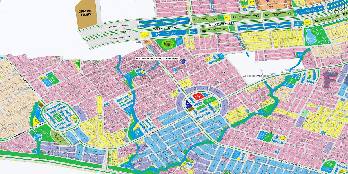
Sector B-17, popularly known as Multi Gardens, is a large and well-planned housing project located at a strategic point in the Islamabad-Rawalpindi metropolitan area. Its layout is organized into several blocks, each with its own unique characteristics and facilities. A comprehensive site layout plan is essential for understanding the zoning, which separates residential plots from commercial areas, parks, and public buildings.
Key elements to look for in the layout include:
- Block Divisions: Familiarize yourself with Blocks A, B, C, D, E, F, and G. Each block has a distinct plan, with varying plot sizes and development statuses.
- Commercial Zones: Identify the main commercial areas, known as Markaz, within the sector. These are hubs for shopping, dining, and business activities.
- Green Spaces: Note the locations of parks, playgrounds, and other green belts. These are crucial for assessing the quality of life and recreational opportunities.
Understanding this structure helps potential buyers and investors make informed decisions based on their preferences for proximity to amenities or quieter residential zones.
Key Access Points and Main Routes
Efficient route planning starts with knowing the main entry and exit points of the society. Sector B-17 is advantageously positioned with multiple access routes, making it easily reachable from various parts of the twin cities. When studying the multi garden b17 map, pay close attention to the primary arteries that connect the society to the larger road network.
The most significant access point is directly from the M-1 Motorway (Islamabad-Peshawar), which gives it an edge for commuters. Another main entrance is located on the main Grand Trunk (GT) Road, providing a vital link to Rawalpindi and Islamabad. Internally, the society is connected by a network of wide, paved roads. Identifying these main boulevards on the map will help you plan your travel efficiently, whether you are visiting for a site survey or commuting daily.
Locating Landmarks and Amenities
A neighborhood is defined by more than just its plots and roads; it’s the landmarks and amenities that create a sense of community. When navigating Multi Garden B-17, using these points of interest as references can make wayfinding much easier.
Look for key landmarks such as:
- Grand Mosque: Often a central feature in a block.
- Educational Institutions: Schools and colleges are prominent markers.
- Hospitals and Clinics: Essential facilities that are easy to locate.
- Community Centers: Hubs for social and recreational activities.
- Water Features: Lakes or water channels that are often highlights of the area.
Amenities like parks, designated parking areas, and rest areas are also clearly marked on detailed maps. For families, identifying family-friendly spots and walking paths is a priority. Knowing where these facilities are in relation to a specific plot can significantly influence a purchasing decision.
Finding Specific Plot Numbers and Addresses
Once you have a general sense of the area, the next step is often to find a specific plot. This is where a detailed map becomes invaluable. Official maps from the MPCHS office provide precise plot numbers, street names, and block information. For investors and home builders, this level of detail is critical for verifying a property’s location.
To find a specific plot, first identify the block (e.g., Block C). Then, locate the street number and finally the plot number. Some modern digital maps even offer coordinates or geotagging features for exact positioning. If you plan to visit the site, you can download a PDF map for offline access or use a navigation app that has updated information for the area. This ensures you can find your way even if mobile service is inconsistent.
Using Digital and Physical Maps
In today’s world, you have multiple options for navigation. Both digital and physical maps have their advantages. An interactive map, often available on a developer’s website, allows you to zoom in, search for specific addresses, and explore the neighborhood virtually. These tools are excellent for initial research. For a site visit, having a physical copy or a PDF download of the multi garden b17 map on your device is a practical tip. This provides a reliable backup.
Effective wayfinding also involves paying attention to on-ground signage. Road signs, block markers, and directional posts within the society are designed to guide visitors. Combining the information from your map with these real-world signs is the most effective way to navigate.
Parking, Safety, and Accessibility
A smooth visit depends on a little planning. If you are visiting Multi Garden B-17 for the first time, keep a few visitors’ information tips in mind. Check the society’s official hours for any offices you need to visit, such as the site office for ticketing or information.
Designated parking areas are usually available near commercial centers and public buildings. For safety, it’s always wise to stick to main roads, especially after dark, and be aware of your surroundings. The society is generally secure, but standard precautions apply. Regarding accessibility, the main roads are well-paved and suitable for all vehicles. If you have specific accessibility needs, it is a good idea to contact the MPCHS office beforehand to inquire about accommodations.
Development and Expansion Plans
Multi Garden B-17 is not a static project; it is continuously evolving. Developers are always working on new blocks and expanding infrastructure. Updated maps will reflect these changes, including the development of new sectors and the addition of more amenities. For long-term investors, staying informed about these expansion plans is crucial, as they can significantly impact property values. Future developments may include new commercial hubs, educational campuses, and recreational facilities, further enhancing the quality of life for residents.
Conclusion
Navigating a large housing society like Multi Garden B-17 is straightforward with the right tools and information. By using an official multi garden b17 map, you can effectively plan your routes, locate key landmarks, and find specific plots with ease. Whether you are an investor evaluating a property, a family planning your future home, or a visitor exploring the area, this guide provides the foundational knowledge for a confident and productive experience. Your journey into this promising real estate landscape begins with understanding its layout, and a good map is your most trusted companion.
Frequently Asked Questions (FAQs)
What is a Multi Garden B17 map?
A Multi Garden B17 map is a detailed plan showing the layout of the MPCHS housing society in Sector B-17, Islamabad. It includes information on blocks, plot numbers, roads, commercial areas, parks, and other amenities to help with navigation and location-finding.
Where can I find an official map of Sector B-17?
Official maps are typically available from the Multi-Professional Cooperative Housing Society (MPCHS) head office or their site office. Digital versions, including PDF downloads and interactive maps, may also be available on their official website.
Does the map show future development plans?
Updated versions of the map often include newly launched blocks or planned future developments. For the most current information on expansion, it is best to consult the latest official maps provided by the developers.