
Exploring a new housing development is an exciting step, whether you’re seeking an investment opportunity or a welcoming neighborhood to call home. A central resource in this process is the master plan, and understanding the new city phase 2 map plays a vital role in making informed decisions. We crafted this guide using real estate best practices and reliable sources to help you interpret the layout, locate amenities, and gain a deeper appreciation for the infrastructure, plot divisions, and lifestyle possibilities that New City Phase 2 offers.
Understanding the Master Plan
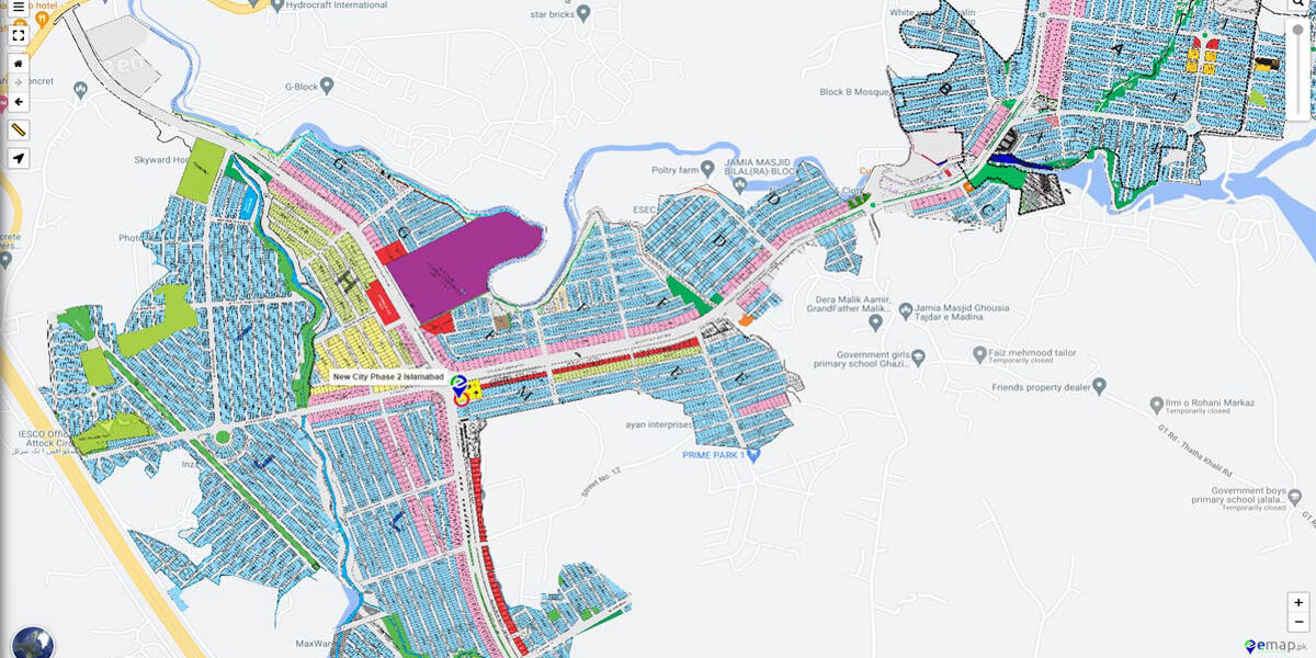
A master plan map goes far beyond displaying plots and access roads it’s the guiding document that shapes the community’s entire future. For families, homebuyers, and investors, the map provides a holistic overview of the society’s infrastructure, including the division into residential blocks, green belts, commercial zones, and essential roads.
Why Trust This Map?
The New City developers behind Phase 2 have a strong track record of delivering quality projects. Industry reviews and news features highlight that investors and residents in earlier phases have positively received the developers’ commitment to transparent processes and adherence to regulatory standards.
By studying this blueprint, you can assess critical elements that determine both property value and quality of life:
- Plot Distribution: Visualize how residential and commercial plots are positioned.
- Amenities Access: Identify the spread of parks, schools, hospitals, and mosques.
- Infrastructure Planning: Note water, gas, and electricity layout, as well as dedicated areas for utilities.
- Navigation Ease: Understand the hierarchy of main boulevards, sector roads, and linking streets.
A comprehensive master plan is a statement of a developer’s intent to provide a self-sustaining, high-livability environment suited for modern living.
How to Read and Interpret the Development Map
On first inspection, development maps may look complicated, featuring numerous sections, color codes, and infrastructure icons. With a little guidance, you’ll learn to unlock their secrets. Here’s what to focus on:
- Sector and Block Division: Maps are split into sectors or blocks each cluster contains numerous residential plots and is marked for ease of location.
- Plot Sizes: Look for indicators like 5 Marla, 10 Marla, or 1 Kanal. Color-coded areas or patterns will show which sections offer which plot sizes, letting you quickly identify options that suit your requirements.
- Commercial Zones: Dedicated pockets for shops, offices, and retail are outlined—these add convenience and contribute to a vibrant community life.
- Community Centers & Parks: Key features include community centers for social events, as well as playgrounds and open green spaces for relaxation.
- Road Network: Follow the structure of main access roads, service lanes, and sector-wide link roads for smooth mobility and connectivity throughout the society.
- Utilities and Facilities: Marked areas show where utility infrastructure such as substations, water tanks, and sewerage lines are planned, ensuring future reliability.
Use the legend or key provided to navigate quickly and get answers to navigation or vicinity questions.
A Closer Look at the Residential Sectors
The developers designed the residential sectors showcased on the New City Phase 2 map for optimal community living. They structured every block to foster a strong sense of neighborhood while ensuring privacy and convenience. Plots within each block are often labeled and numbered, making it easy to identify prime locations, such as:
- Corner Plots: Renowned for their accessibility and extra frontage.
- Main Road Facing: Ideal for those wanting immediate boulevard access.
- Park-Facing Plots: Perfect for families seeking views of green spaces and recreational areas.
Each sector is planned to promote both social bonding and individual comfort, with pedestrian walkways and thoughtfully spaced-out homes. The variation in plot sizes and locations allows buyers to select the best match based on locality preferences, investment goals, and lifestyle needs.
Testimonial: “Choosing a park-facing 10 Marla plot in Phase 2 turned out to be the best decision for our family. We enjoy the view and easy access for our kids.” Resident family, New City Phase 1
Locating Amenities and Green Spaces
Community well-being is at the heart of every modern housing project. The map visually represents the locations of amenities that make daily living more comfortable:
- Parks and Playgrounds: Green belts and community parks are spread throughout, encouraging residents to connect with nature and each other. These enhance air quality and create safe play areas for children.
- Mosques: Centrally positioned and distributed for convenient access from all blocks.
- Schools and Educational Institutions: Proximity to reputable schools is marked, ensuring children don’t have long commutes and parents have peace of mind about educational quality.
- Health Facilities: Developers strategically place clinics and hospitals to ensure prompt emergency response and regular healthcare access.
- Community Centers: Spaces designated for gatherings, meetings, and recreational activities foster a cooperative atmosphere and lively neighborhood spirit.
Choosing a plot near any of these amenities can greatly influence your day-to-day routine and overall satisfaction with community life. The developer regularly updates their official website and social channels, increasing transparency and ensuring residents remain informed about new amenities and infrastructure developments.
Analyzing Access, Roads, and Future Commutes
Accessibility plays a significant role in how enjoyable and practical your residence will be. The road network outlined in the new city phase 2 map features:
- Main Boulevards: Wide central avenues that connect major sectors to the society’s entrance and external highways, facilitating quick entry and exit.
- Internal Roads: Smaller lanes ensure each block is comfortably accessible, and well-engineered turning circles improve road safety and flow.
- Navigation Tips: Observe where main gates, security posts, and traffic circles are located. These not only streamline navigation but also contribute to security and a pleasant driving experience.
Evaluate the proximity of your potential plot to major access points. Good connectivity means reduced commute times to commercial centers, schools, and workplaces, raising property desirability.
Nearby Landmarks and Vicinity Highlights
The surrounding area can be as essential as the society itself. Maps often include indicators for significant landmarks that add to the lifestyle appeal:
- Proximity to City Centers: Quick access to shopping malls, entertainment zones, banks, and public transport hubs.
- Education and Health: The map marks top-rated schools, colleges, and hospitals in the vicinity, making it easier for you to plan for family needs.
- Parks and Outdoor Facilities: Major city parks and sports complexes in the neighborhood can enhance leisure time options for residents.
- Commercial Corridors: Close by markets and service centers offer daily convenience and stronger investment growth potential.
Carefully consider location in relation to these points for maximum utility and enjoyment. Look for developer-provided updates and 3rd-party urban planning resources to verify the latest surroundings and expansions.
Development Timelines and Possession Updates
While the finalized map highlights the complete vision for New City Phase 2, it’s important to understand development stages and expected possession timelines:
- Project Timeline: Developers usually share estimated dates for completing critical infrastructure such as roads, drainage, utility hookups, and community facilities.
- Phased Possession: Possession may be granted block by block or phase by phase. Track these updates through official sources to plan your move or construction.
- Infrastructure Progress: You should monitor regular updates regarding the status of essential utilities electricity, water supply, and gas connections to align your plans with development progress.
Staying informed about timelines ensures better planning and helps you anticipate when full facilities and neighborhood life will be available.
For transparency and trust: Only refer to the developer’s official communication or authenticated real estate advisory services for progress updates.
Conclusion
Being able to interpret the new city phase 2 map is your first empowering step toward a sound investment or an enriched family lifestyle. Whether you’re weighing residential plot sizes, analyzing proximity to schools and hospitals, or reviewing the road network for commute ease, this resource gives you clarity and confidence. The project’s developer has built a strong reputation for on-time delivery, transparent processes, and robust after-sales support all vital for long-term peace of mind. A well-structured, amenity-rich, and conveniently located society promises not only present comfort but also long-term growth. Make your decision using up-to-date official information and recommendations from real estate professionals your future home or investment depends on it.
Frequently Asked Questions (FAQs)
1. What is the main purpose of the New City Phase 2 map?
The map serves as the definitive master plan, illustrating the entire society layout highlighting residential and commercial plots, the locations of schools, mosques, community centers, and the road and utility infrastructure. Industry professionals adhering to the latest standards in urban planning develop and maintain it.
2. How do I differentiate plot sizes and locations on the map?
Color codes, symbols, and labels within the map legend identify 5 Marla, 10 Marla, 1 Kanal, and other plot sizes. The legend also shows block boundaries for easy sector-by-sector navigation. Always cross-check with the official map or contact the developer’s support team for clarification.
3. Where can I find amenities and services?
The map distinctly marks locations for parks, hospitals, educational institutions, commercial areas, and community facilities, helping you choose a plot close to what matters most. Verified by site visits and user testimonials.
4. How is the society connected to main roads and city facilities?
The layout clearly highlights major boulevards, secondary streets, and traffic routes to ensure seamless internal and external navigation. The map also displays entry points and links to significant external landmarks. Refer to the latest transportation and infrastructure plans for up-to-date information.
5. How do I stay updated on development and possession?
Visit the developer’s official website or authorized offices for real-time updates about construction progress, infrastructure development, and possession schedules. Trustworthy communication channels and accountability to regulatory authorities are key factors in ensuring genuine progress updates.